Geoshot...
GIS Data Processing services
Unleash the Potential of Spatial Data with GeoShot Technologies
At GeoShot Technologies, a premier GIS Mapping Company, we specialize in GIS data processing that empowers individuals, businesses, and organizations to harness the capabilities of spatial data for insightful decision-making and precise analysis. By combining advanced technology with deep industry expertise, we deliver innovative solutions tailored to meet the unique needs of our clients. Whether you are managing land, optimizing layouts, or analyzing geographic trends, GeoShot Technologies is your trusted partner for unlocking the full potential of spatial data.

Why Choose GeoShot Technologies for GIS Solutions?
With years of experience in GIS mapping and data processing, we have developed a reputation for delivering top-notch services that cater to a wide spectrum of industries. Our team is committed to accuracy, innovation, and customer satisfaction. We understand that spatial data is more than just coordinates and maps—it’s a powerful tool that drives intelligent decisions, enhances operational efficiency, and transforms how you view the world.
Here’s how our services can help you make the most of your GIS investments:
Our Services
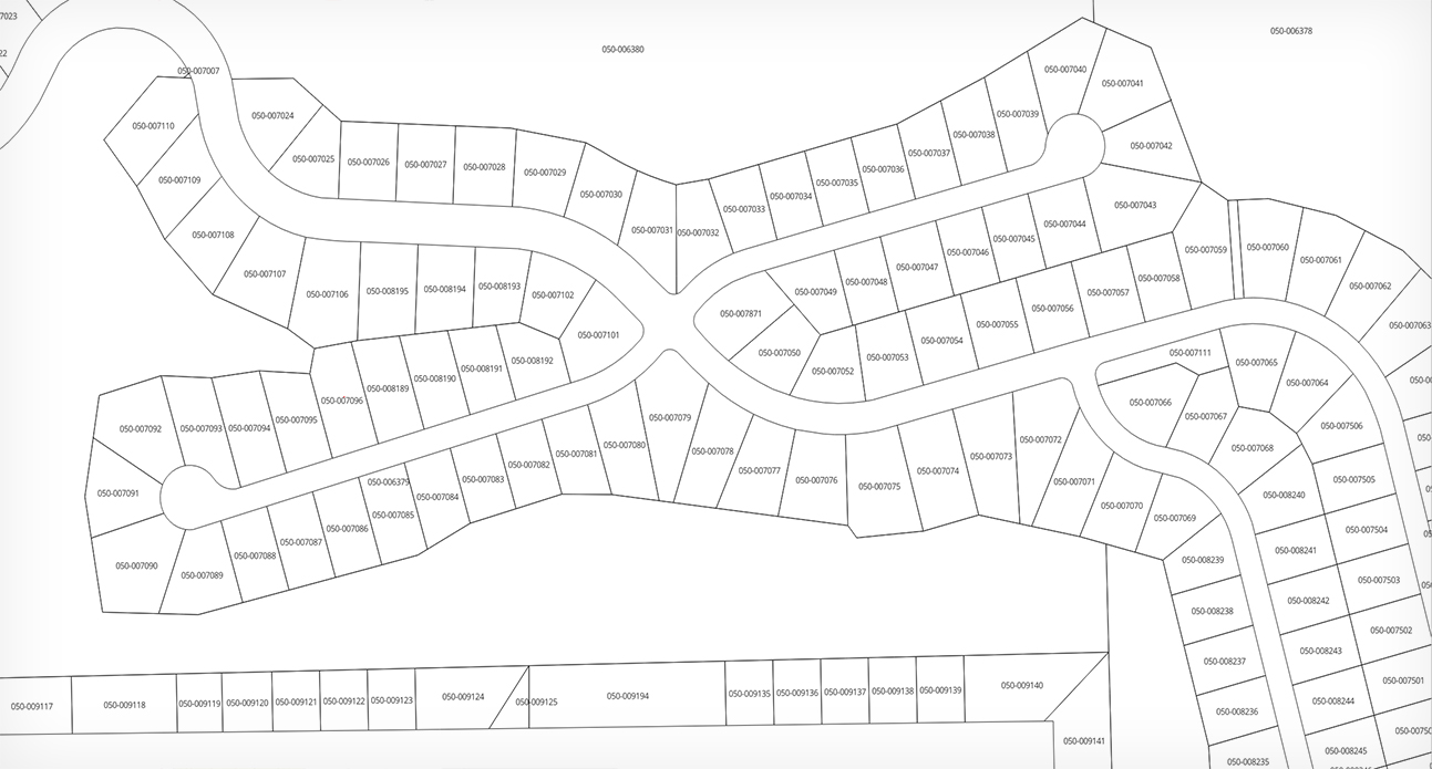
Parcel & Cadastral Mapping
GeoShot Technologies offers precise parcel and cadastral mapping solutions. By leveraging advanced GIS tools, we create detailed maps of land parcels and cadastral boundaries, aiding in efficient land management and dispute resolution. Our mapping services cater to municipalities, real estate firms, and land management authorities, helping them maintain up-to-date records and streamline property-related processes.
Accurate cadastral maps play a crucial role in urban planning, taxation, and land registration. Our expertise ensures that your data is consistent, reliable, and ready for integration with other systems.
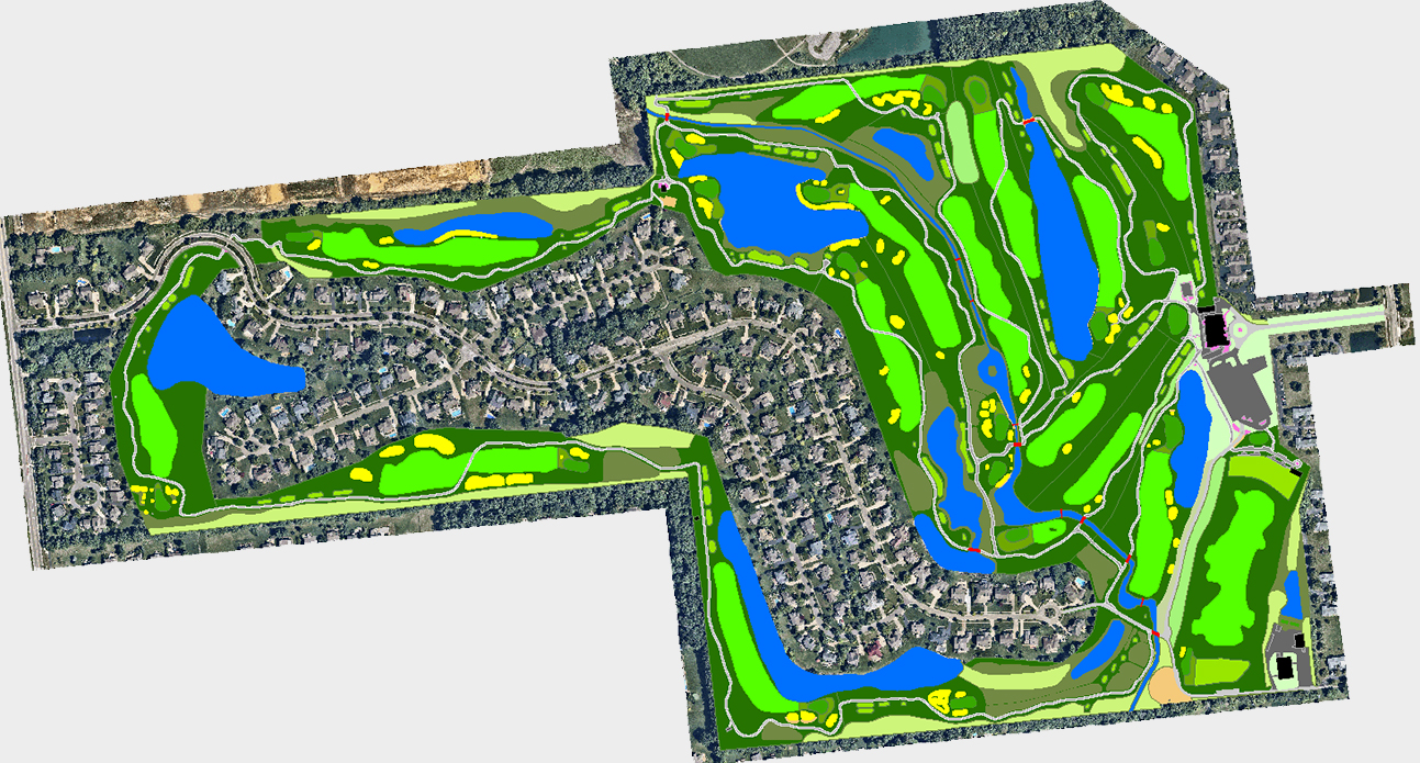
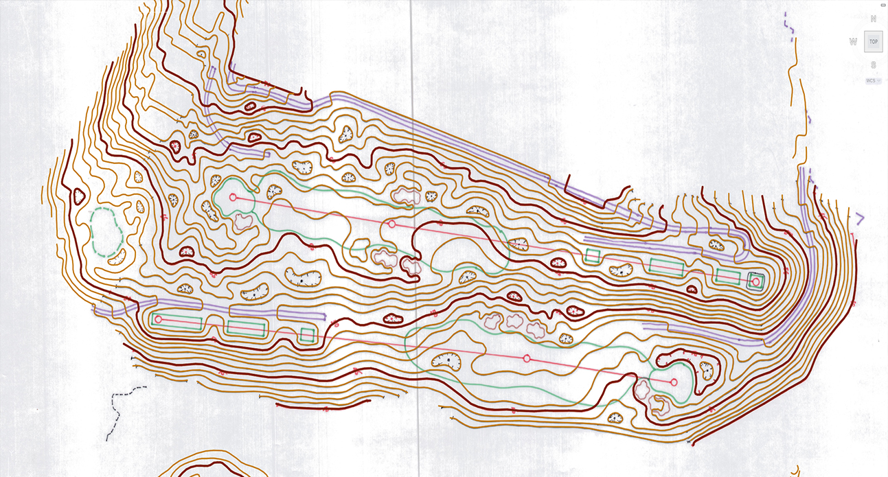
Golf Course Mapping
For golf course operators and designers, GeoShot Technologies provides comprehensive GIS mapping services tailored to the unique needs of the golfing industry. We create detailed layouts of golf courses, showcasing features such as fairways, greens, hazards, and other critical elements.
Our mapping services help golf course managers optimize course design, enhance maintenance schedules, and improve the overall player experience. With our accurate and visually appealing maps, you can make strategic decisions to elevate your facility’s performance and reputation.
GIS Data Conversion & Digitization
One of the key challenges in managing spatial data is ensuring it is accessible, usable, and consistent. GeoShot Technologies offers cutting-edge GIS data conversion and digitization services to transform analog or outdated datasets into modern digital formats.
Our solutions eliminate inconsistencies and improve data quality, enabling seamless integration with GIS platforms. Whether you need to digitize historical maps, convert formats, or standardize data across systems, we ensure that your information is accurate, scalable, and ready for analysis.
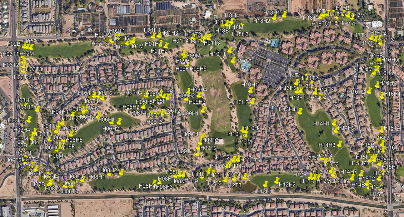
Golf Course Hazard Database
As part of our specialization in golf course mapping, we maintain an extensive database of hazards for over 36,000 golf courses worldwide. Our GIS data processing identifies and catalogs features such as bunkers, rough areas, water hazards, and other obstacles.
This information is invaluable for golfers, GPS devices, and mobile applications, helping players navigate courses and refine their strategies. Whether you are developing a golf-related app or seeking insights into course design, our hazard database is a comprehensive resource that meets your needs.

The Value of GIS Data Processing
Spatial data processing lies at the heart of effective GIS implementation. At GeoShot Technologies, we leverage advanced tools and methodologies to extract meaningful insights from geographic data. Our solutions empower clients to:
- 1. Visualize Spatial Relationships: Understand how features interact across a landscape, providing a clearer picture for analysis and planning.
- 2. Make Informed Decisions: With accurate GIS data, organizations can strategize effectively, from urban development to natural resource management.
- 3. Optimize Operations: Efficiently manage assets, resources, and workflows using spatial insights.
Our team ensures that your GIS data is processed with precision, enabling you to unlock its full potential.
Applications of GIS in Diverse Sectors
GIS is a transformative tool used across various industries. Here’s how our GIS Mapping Company supports different domains:
- Urban Planning: Accurate parcel mapping aids city planners in zoning, infrastructure development, and land-use analysis.
- Real Estate: Detailed cadastral maps help real estate firms and developers in property valuation, boundary disputes, and asset management.
- Golf Industry: Our specialized services enhance course design and the user experience.
- Environmental Studies: GIS is crucial for analyzing ecosystems, tracking changes, and planning conservation efforts.
- Infrastructure Development: Spatial data supports the planning, construction, and maintenance of roads, pipelines, and utilities.
Our team ensures that your GIS data is processed with precision, enabling you to unlock its full potential.

Why GeoShot Technologies Stands Out
- Expertise in GIS Technologies: We stay at the forefront of advancements in GIS tools and software, ensuring that our clients benefit from the latest innovations.
- Custom Solutions: Every project is unique, and we tailor our services to match the specific requirements of our clients.
- Global Reach: With experience working on projects worldwide, we bring a wealth of knowledge and a broad perspective to every task.
- Commitment to Excellence: Quality is at the core of everything we do, from data accuracy to client communication.
Let’s Collaborate on Your Next GIS Project
Ready to leverage the power of spatial data for your business or organization? GeoShot Technologies is here to guide you every step of the way. From parcel mapping to GIS data processing, we provide solutions that drive results and unlock new possibilities.
Contact us today at email.geoshott@gmail.com to discuss your project requirements. Let’s explore how our expertise can help you achieve your goals and transform the way you utilize geographic information.
Key Takeaways
- GeoShot Technologies offers specialized services in parcel mapping, golf course mapping, GIS data conversion, and hazard database creation.
- Our solutions empower organizations to make better decisions, optimize workflows, and visualize spatial relationships.
- With experience, innovation, and a commitment to quality, we are a reliable partner in GIS solutions.
Don’t let your spatial data go untapped. Partner with GeoShot Technologies, the trusted GIS Mapping Company, and unlock its full potential with cutting-edge GIS data processing solutions.
Send a Message
