Geoshot...
- Home
- / Our Blogs
Our Blogs
How is LiDAR data processing changing the development approach?
About LiDAR Technology
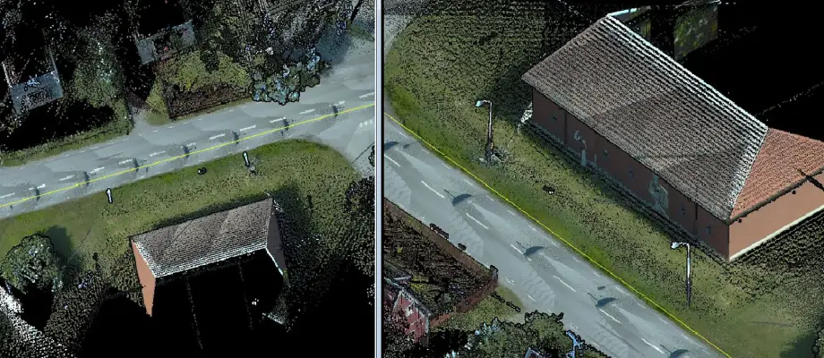
Before diving into LiDAR data processing services, it is important to understand the basics of LiDAR technology. LiDAR is a remote sensing method that uses laser light to measure distances and create accurate 3D representations of objects and surfaces. This is accomplished by sending a laser pulse and measuring the time it takes for it to bounce back after hitting a surface. By calculating the flight times of these laser pulses, LiDAR systems can determine the distance to an object with incredible accuracy. These data are usually processed by specialized companies offering LiDAR data processing services, such as GeoShot Technologies.
The Importance of LiDAR Data Processing
Key Aspects of LiDAR Data Processing:
- Point Cloud Classification: Raw LiDAR data consists of millions of points in 3D space. These points need to be classified such as soil, vegetation, buildings, and more. This 3D Point Cloud Classification is essential for creating accurate terrain models and identifying objects of interest.
- Background Extraction: Identifying the background surface is critical for applications like topographic mapping and flood modeling. With Point Cloud Classification, the earth's surface can be extracted accurately, providing clear insights into the terrain.
- 3D Modeling: LiDAR data is used to create highly detailed 3D models of buildings, cities, and landscapes. These models are invaluable for urban planning, architectural design, and simulations.
- Feature Extraction: Specific features such as power lines, utility poles, and trees can be identified and extracted using LiDAR data. This information is particularly valuable for industries like utilities and forestry.
- Contour Line Generation: LiDAR data enables the creation of highly accurate contour lines, representing elevation changes on maps. This is essential for civil engineering and land development projects.
How LiDAR Data Processing is Transforming Industries
LiDAR Data Processing Services are revolutionizing development across industries worldwide. Here’s a glimpse:
- Urban Planning: Urban planners use LiDAR data to create detailed 3D renderings of urban areas, aiding infrastructure development, traffic management, and disaster preparedness.
- Environmental Monitoring: LiDAR helps monitor and assess environmental changes, including deforestation, coastal erosion, and wetland protection.
- Transportation: LiDAR-equipped vehicles collect data for road and rail surveys, contributing to safer and more efficient transportation systems.
- Archaeology: LiDAR technology allows researchers to uncover hidden archaeological features, offering new insights into ancient civilizations.
- Agriculture: LiDAR Data Processing Services support farmers with crop management, soil analysis, and precision agriculture to optimize yield and resource utilization.
Conclusion
LiDAR technology, when combined with LiDAR Data Processing Services, opens the door to groundbreaking advancements across numerous industries. The ability to perform 3D Point Cloud Classification and extract meaningful insights from Point Cloud Classification is vital for creating accurate models, optimizing designs, and supporting decision-making. As industries continue to adopt LiDAR technology, the demand for expert LiDAR Data Processing Services will only grow, driving innovation and shaping the future of development across the globe.
Warning: include(side-blogs.php): Failed to open stream: No such file or directory in /home/dpj4klqxgf6s/public_html/how-lidar-data-processing-is-changing-the-development-approach.php on line 110
Warning: include(): Failed opening 'side-blogs.php' for inclusion (include_path='.:/opt/alt/php81/usr/share/pear:/opt/alt/php81/usr/share/php:/usr/share/pear:/usr/share/php') in /home/dpj4klqxgf6s/public_html/how-lidar-data-processing-is-changing-the-development-approach.php on line 110
