Skip to content
  • Home
  • About
  • Services
    • 3D Architectural Visualization
    • Augmented Reality 3D Models
    • 3D Modeling for Games
    • Golf Course Visualization
      • Golf Course Flyover
      • Golf 3D Still Render
      • 2D Golf Graphics Design
      • 3D Golf Graphics Design
    • Geospatial Services
      • GIS Data Processing
      • LiDAR Data Processing
      • UAV Data Processing
      • Golf Course Mapping
    • CAD Drafting Services
      • Golf CAD Drafting
      • Cut and Fill Calculation
    • Map Illustrations
    • Graphic Design
    • Landscape Rendering Services
    • CAD Conversion and 3D Modeling
    • bookkeeping
    • Search Engine Optimization
  • Industries
    • Gaming
    • Golf
    • AEC Industry
    • E-commerce
    • Print and Digital Media
  • Careers
  • Blog
  • Contact Us
Need help? Mail To: email.geoshott@gmail.com
UAV data Processing

How UAV and LiDAR Data are Transforming Smart City Infrastructure

November 3, 2025
 |  No Comments
 |  Lidar Data Processing

The use of UAV and LiDAR for Smart Cities has become necessary in a world that is urbanizing at an exponential rate, to be able […]

Lidar data processing

How is LiDAR data processing changing the development approach?

October 8, 2025
 |  No Comments
 |  Lidar Data Processing

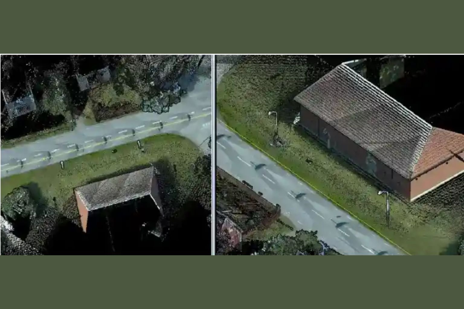
About LiDAR Technology Before diving into LiDAR data processing services, it is important to understand the basics of LiDAR technology. LiDAR is a remote sensing […]

3D point cloud classification

Behind the Scenes of LiDAR Data Processing

September 22, 2025
 |  No Comments
 |  Lidar Data Processing

LiDAR (light detection and ranging) has become an innovative tool for collecting high-precision spatial data. This data is important in a variety of industries, from […]

Contact Us


0 / 180

Recent Post

  • Understanding the Complete Golf Course 3D Visualization Workflow
  • How 3D Map Illustrations Improve Accuracy and User Experience
  • Vector vs Bitmap Graphics in Adobe Illustrator: What’s the Difference
  • Beyond Static Images: How to Create Interactive Maps Like Google Maps
  • How 3D Visualization in Construction Bridges the Gap Between Design and Reality
  • 3D Architectural Visualization
  • 3D Modeling for Games
  • Augmented Reality 3D Modeling
  • Blog
  • CAD Drafting Services
  • GIS Data Processing
  • Golf Course Mapping
  • Golf Course Visualization
  • Lidar Data Processing
  • Map Illustrations
  • UAV Data Processing
Welcome to GeoShot Technologies, a hub for cutting-edge technology solutions. It was established in 2013, as a company dedicated to revolutionizing various industries through advanced digital visualization and spatial analysis.
Our Services
3D Architectural Visualization
Augmented Reality 3D Modeling
3D Modeling for Games
Golf Course Visualization
Geospatial Services
CAD Drafting Services
Map Illustrations
Contact Us

GeoShot Technologies
SF-30, 2nd Floor, Omaxe Celebration Mall, Sohna Rd, Near Subhash Chowk, Gurugram, Haryana 122001

  • +91-98108 18698
  • email.geoshott@gmail.com

© 2026 Geoshot Technologies | All rights reserved